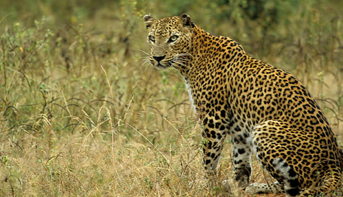
Wild Life

Feel the wondering variety of wild life and bio diversity in this little island

Surfing

Arugam Bay in east cost of Sri lanka is the one of best places in earth for surfing.

White Water Rafting

The small town of Kitulgala in the hill country is the most famous whitewater rafting location in Sri Lanka.

Goldi Sand Beaches

Experience the Miracle Beaches

Cultural Events

Kendy Perahara

Showing posts with label National Park. Show all posts

Friday, December 21, 2012

Beautifull Pictures of Sri Lanka

Hathmale Falls - Deniyaya

Horton Plains 

Laxapana Falls

Patanangala Beach - Yala National Park

National Botanical Garden - Peradeniya

Reverstan Peak - Knuckles Mountain Range

Bambarakanda Falls 

Bomburu Ella - Welimada

Bopath Ella - Kuruwita, Ratnapura

Nilaveli Beach

National Botanical Garden - Peradeniya

Saturday, October 20, 2012

Minneriya National Park

Minneriya National Park is situated in the north-central plains of Sri Lanka, 20 kilometers from Polonnaruwa. Even though it is one of the smallest national parks in the country, covering just 8,889 hectares, it’s a paradise with many natural wonders. The park encompasses the beautiful Minneriya tank, built by King Mahasena (in 3rd century AD). This tank is an incredible place to observe the elephants that come to bathe and graze on the grasses as well as the huge flocks of birds (cormorants, painted storks, open-bills, Pelicans and many other species of waders) that come to fish in the shallow waters.

Getting There

Main entrance of Minneriya National park is located facing Habarana – Polonnaruwa road (A11). From Colombo reach Habarana junction via Kurunegala, Dambulla (A1, A6), and take the right turn from Habarana towards Polonnaruwa. Drive 10 km towards Polonnaruwa to reach Minneriya National Park. Distance from Colombo is around 182km and total driving time will be around 4-5 hours.

Weather and Season

Best months to visit Minneriya are the dry months from June to September. Hundreds of elephants from the surrounding area are attracted to the drying Minneriya lake bed, which turns in to a lush green grass land, for food and water. Generally you can observe around five to ten herds of elephants, each with anything from twenty to fifty individuals of all age groups.


History and the Description of the Minnariya National Park:

A flapping sea of black invades the emerald Minneriya Tank, as a flock of two thousand cormorants nosedive for fish. The elephants too, trudge by drinking from the same reservoir.

Not close to being the largest tank in Sri Lanka , Minneriya Tank - with the woods that surround it forming the Minneriya-Giritale National Park - is nevertheless home to an extraordinary diversity of wildlife. If numbers interest you, there are nine species of amphibians, 24 species of mammals, 25 species of reptiles, 26 species of fish (three of which are endangered), 75 species of butterflies and 160 species of birds.

Making your way through the park, you will see elephants, Spotted Deer and also the Sambar, which is a deer with no spots and an apt scientific name, carves unicolor . If you're lucky, a leopard looking for food might cross your path.

Less menacing but equally intriguing are the frogs and lizards with their tongues ready. Among the reptiles, the Red-lipped Lizard and Skink are both endemic to Sri Lanka as well as endangered. The frogs, on the other hand, are more abundantly present and have a tendency to jump over your feet or across your eyes between leaves. A notable example with a formidable but misleading title is the Sri Lanka Greater Hourglass Tree Frog.

It all sounds like there's such a lot to see at the park. But overhead is where the action really is. Sri Lanka , home to over 400 species of birds, has long been a birdwatcher's paradise. In Minneriya National Park alone, 160 species crowd the trees or strut the banks.

You can afford to miss the Painted Storks, Great White Pelican, Gray Herons, and even the Ruddy Turnstones (whatever those are). But do try to spot the Sri Lanka Jungle Fowl, Sri Lanka Hanging Parrot, Sri Lanka Brown-capped Babbler and Sri Lanka Gray Hornbill, because, as you can guess from their names, nowhere else are you going to find them but here, in Sri Lanka.

Even if you're not a bird enthusiast, at least you can boast about your trip later by throwing around some exotic bird-names.

Sunday, September 16, 2012

Kudiramalai Point


Kudiramalai  is a headland cape, point and ancient port town on the west coast of Sri Lanka. It was once a flourishing emporium of international trade and the capital of an ancient Kingdom based in Jaffna peninsula of the Naka, before the capital was moved to Nallur in the medieval period. Situated on the Gulf of Mannar's coast close to Silavaturai, the town has a shared history with the proximally located Karaitivu island, the ancient port town of Mannar and the historic and famous Thiruketheeswaram temple. Kudiramalai is the northernmost point of the Puttalam District, and proved to be a useful subsidiary southern port of Mannar in the classical period, serving the island's northern kingdoms of the Jaffna Peninsula and Vanni country as one of their southernmost border towns. It lies directly west across the Vanni from Trincomalee (Thiru-Konamalai), home of the historic Koneswaram temple. The shores from Kudiramalai point 20 km north up to Vankalai village formed the most famed pearl fishing banks in the classical and medieval eras.
Famous rulers of this land included Queen Alli Arasani, Chief Korran, his father Pittan, and Korran's contemporaries Chief Elini and Athiyamān Nedumān Añci (father/son duo) and Kumanan. Traders brought several horses in watercraft to the island during the Sangam period. The port was known as Hippuros to ancient Greeks (literal translation of Kudiramalai in Greek - Horse Mount/Hill) and finds mention in the Periplus of the Erythrean Sea of Ptolemy. Archaeological excavations have revealed Kudiramalai to have been a site of ancient habitation from the 1st century BCE-to the 7th century CE and later. Kudiramalai's ruins attract visitors from around the world. It is now a barren dry zone landscape, with red earth terrain typically seen in Northern and North Western Sri Lanka, and sand dunes once serving as sites of habitation.

Source - Click here


Thursday, August 9, 2012

Madu River - Balapitiya

Madu River which flows across Balapitiya (approx 80kms down south) is one of the rarely visited and unspoiled attractions any nature lover can find in Sri Lanka. She boasts of having a cluster of 64 small islands scattered along her path and the most of which are uninhabited and covered with mangroves. The largest is known as "Ma Doowa" where about 300 families live and the smallest is called "Satha Paha Doowa". According to folklore this islet had been purchased for five cents but some say the name has derived due to its shape. “Kurundu Doowa (Cinnamon isle) is one of the attractions of river where the dweller Pemadasa maintains a cinnamon plantation. The main attraction of all is "Koth Doowa" which is housed to a serene Buddhist temple with a statue of Lord Buddha and a venerated old Bo (pipal) tree. The river and the islands also provide shelter to many fauna and flora. But over enthusiastic nature lovers are forewarned! - Madu River is also a den for crocodiles.


Baby crocodile in the Madu River


Koth Doowa Viharaya

Tuesday, June 19, 2012

Kumana National Park & Birds Sanctuary


Kumana National Park covers an area of about 18, 149 hectare of land. It is located in the south-east part of Sri Lanka. This bird sanctuary is an attraction for bird watchers.  Kumana is contiguous with Yala National Park. Kumana was formerly known as Yala East National Park, but changed to its present name in 5 September 2006.  The park was reopened in March 2003 after it was closed since 1985 due to Civil War in Sri Lanka.
There is a swamp lake of about 200 hectare known as Kumana Villu in Kumana National Park. During the months of May and June numerous species of water birds nest around the swampy area.
At Kumana National Park, birds like herons, egrets, white ibis, spoonbills, painted storks and pelicans can be easily spotted in Kumana National Park. Very rare species of black necked storks, great thick knee, Eurasian spoonbill etc are also found in this national park of Sri Lanka. The fauna of Kumana National Park is mainly of mangrove variety. Kumbuk trees and karan fern trees also grow in this region.
In Kumana National Park different varieties of animals like wild boar, elephant, European otter, golden jackal and fishing cat are found. Indian black turtle, flap shelled turtle, mugger crocodile can be also seen here.

Physical features

Kumbukkan Oya forms the southern boundary of the national park. Some 20 lagoons and tanks support the extensive birdlife of the national park. The lagoons are shallow with depths less than 2 metres (6.6 ft). Kumana villu is subject to occasional inundation with seawater. The elevation of the area ranges from sea level to 90 metres (300 ft). The mean annual temperature is 27.30 °C (81.14 °F) and the area receives 1,300 millimetres (51.18 in) of annual rainfall.

Flora

The park's wetland areas are surrounded by dry zone tropical thorn forest. The inland forest's flora is dominated by Manilkara hexandra (Sinhalese "Palu"), Hemicyclea sepieria, Bauhinia racemosa, Cassia fistula ("Ehela"), Chloroxylon swietenia ("Burutha"), and Salvadora persica species. The dominant tree of the Kumana villu is Sonneratia caseolaris, while Typha angustifolia is the dominant reed. Terminalia arjuna trees dominate the riverine forests along the Kumbukkan Oya. The common aquatic plants of the swamp are colourful Ludwigia spp., Nelumbo nucifera, Nymphaea pubescens, Aponogeton spp. and Neptunia oleracea.


Location 


View Larger Map

Source - Click here

Friday, June 15, 2012

Bundala National Park & Bird Sanctuary

Located about fifteen kilometers east of Hambantota Bundala National Park is one of Sri Lanka's foremost destinations for birdwatchers, protecting an important area of coastal wetland famous for its abundant aquatic (and other) birdlife. Bundala was designated a wildlife sanctuary in 1969 and redesignated to a national park on 4 January 1993. In 1991 Bundala became the first wetland to be declared as a Ramsar site in Sri Lanka. In 2005 the national park was designated as a biosphere reserve by UNESCO, the fourth biosphere reserve in Sri Lanka. The national park is situated 245 kilometres (152 mi) southeast of Colombo. The park is also home to significant populations of elephants, Marsh & estuarine crocodiles, turtles & other fauna, including the leopard. Stretching along the coast east of Hambantota, Bundala National Park is ideal for instant gratification: in a four hour jeep ride, we can see elephants, 8ft crocs, giant squirrels & flamingoes. Afternoon safaris in the dry season (December - May) provide visitors with the best chance of seeing the wildlife.


History

The area was declared a wildlife sanctuary on 5 December 1969,and was upgraded to a national park on 4 January 1993 with land area of 6,216 hectares (24.00 sq mi). However the park was regazetted in 2004 and the original park was reduced to 3,698 hectares (14.28 sq mi). In 1991, Bundala became the first site in Sri Lanka to be designated a Ramsar wetland. In 2005, Bundala was declared a Man and Biosphere Reserve by UNESCO. In January 2006, an area adjacent to Bundala covering an area of 3,339.38 hectares (12.8934 sq mi) was declared as the Wilmanna Sanctuary.

Physical features

The area mainly underlain with hornblende-biotite gneiss of the eastern Vijayan series.The low country dry zone climate prevails in the area. The area have an average relative humidity of 80%. The national park contains five shallow, brackish lagoons with salt pans in three. They are Bundala lagoon of 520 hectares (2.0 sq mi), Embilikala lagoon of 430 hectares (1.7 sq mi), Malala lagoon of 650 hectares (2.5 sq mi), Koholankala lagoon of 390 hectares (1.5 sq mi), and Mahalewaya of 260 hectares (1.0 sq mi). The Koholankala and Mahalewaya are almost totally developed for salt production. The climatic conditions are tropical monsoonal, with a mean annual temperature of 27 °C (81 °F). Annual rainfall ranges from 900–1,300 millimetres (35–51 in), with dry period persists from May to September.The elevation of the park ranges from sea level to 10 metres (33 ft).The park was affected by 2004 Indian Ocean tsunami. Due to protection from sand dunes the park received very little damage.


More Facts - Click here

Wednesday, May 23, 2012

Udawalawe National Park


Udawalawe National Park lies on the boundary of Sabaragamuwa and Uva Provinces, in Sri Lanka. The national park was created to provide a sanctuary for wild animals displaced by the construction of the Udawalawe reservoir on the Walawe River, as well as to protect the catchment of the reservoir. The reserve covers 30,821 hectares (119.00 sq mi) of land area and was established on 30 June 1972. Before the designation of the national park, the area was used for shifting cultivation (chena farming). The farmers were gradually removed once the national park was declared. The park is 165 kilometres (103 mi) from Colombo. Udawalawe is an important habitat for water birds and Sri Lankan Elephants. It is a popular tourist destination and the third most visited park in the country.


Physical features

Udawalawe lies on the boundary of Sri Lanka's wet and dry zones. Plains dominate the topography, though there are also some mountainous areas. The Kalthota Range and Diyawini Falls are in the north of the park and the outcrops of Bambaragala and Reminikotha lie within it. The park has an annual rainfall of 1,500 millimetres (59 in), most of which falls during the months of October to January and March to May. The average annual temperature is about 27–28 °C (81–82 °F), while relative humidity varies from 70% to 82%. Well-drained reddish-brown soil is the predominant soil type, with poorly drained low humic grey soils found in the valley bottoms. Mainly alluvial soils form the beds of the watercourses.

Ecology

The habitat surrounding the reservoir includes marshes, the Walawe river and its tributaries, forests and grasslands. Dead tree standing in the reservoir are visual reminders of the extent of forest cover before dam construction. Green algae, including Pediastrum and Scenedesmus spp., and blue green algae species such as Microsystis, occur in the reservoir. Areas of open grassland are abundant as a result of former chena farming practices. There is a plantation of teak beyond the southern boundary, below the dam, which was planted before the declaration of the park. Species recorded from the park include 94 plants, 21 fish, 12 amphibians, 33 reptiles, 184 birds (33 of which are migratory), and 43 mammals. Additionally 135 species of butterflies are among the invertebrates found in Udawalawe.

Flora

Hopea cordifolia, Memecylon petiolatum, Erythroxylon zeylanicum, and Jasminum angustifolium are endemic floral species recorded from the park. Hopea cordifolia is found along the river along with Terminalia arjunaPanicum maximum and Imperata cylindrica are important food sources for the elephants. Chloroxylon swietenia, Berrya cordifolia, Diospyros ebenum, Adina cordifolia, Vitex pinnata, Schleichera oleosa, and Diospyros ovalifolia are the common taller trees. Terminalia bellirica and Phyllanthus emblica are plants of medicinal value found in the forest. Cymbopogon confertiflorus grass species and Grewia tiliifolia bushes are common in the grasslands.

Source -  Click here

Sunday, May 20, 2012

Wasgamuwa National Park


Wasgamuwa National Park is a natural park in Sri Lanka situated in the Matale and Polonnaruwa Districts . It was declared to protect and to make a refuge for the displaced wild animals during the Mahaweli Development Project in 1984 and is one of the four National Parks designated under the Project. Originally it was designated as a nature reserve in 1938, and then in the early 1970's the area was regraded as a strict nature reserve. Wasgamuwa is one of protected areas where Sri Lankan Elephants can be seen in large herds. It is also one of the Important Bird Areas in Sri Lanka. The name of the Wasgamuwa has derived through the words "Walas Gamuwa". "Walasa" is Sinhala for Sloth bear and "Gamuwa" means a wood. The park is situated 225 km away from Colombo.

Elephant at Wasgamuwa

Leopard at Wasgamuwa


Physical features

The National Park's annual daily temperature is 28 °C (82 °F) and has a dry zone climate. Annual rainfall ranges between 1650-2100 mm. Rain is received during the north-eastern monsoon, from October to January. July-September is the dry season. Highest elevation of the National Park is Sudu Kanda (White mountain), which is 470 metres (1,540 ft) of height. The soil of the national park contains quartz and marble. The forests of Wasgamuwa represent Sri Lanka dry-zone dry evergreen forests. The park consists of primary, secondary, riverine forests and grasslands.

History and historic irrigation

Ruins of Malagamuwa, Wilmitiya, Dasthota irrigation tanks and Kalinga Yoda Ela canal which are built by Parākramabāhu I remain in the national park. In the past water was irrigated from the Minipe anicut's left bank canal to Parakrama Samudra by Amban ganga which had run through Wasgamuwa.


Yudangana Pitiya has identified as the battleground of the battle between King Elara and King Dutthagamani taken place. A grassland that the Dutthagamani's army supposed to have camped before the battle is known as Kandauru Pitiya. The ruins of Chulangani chaitya which is built by King Mahanaga can be seen in the national park. Its circumference, 966 feet (294 m) is greater than the Ruwanwelisaya's. The artifacts that have been recovered from the bricks of the chaitya include a bowl used by King Sri Vikrama Rajasinha and several bronze statues are now kept in the Yudangana vihara.

Flora

Wasgamuwa National Park exhibits one of the highest biodiversity among the protected areas in Sri Lanka. More than 150 floral species have recorded from the park. Cryptocoryne walkeri and Munronia pumila are two plants with economic value. Reservoirs and riverine forests support large number of fauna species. The forest consists of several layers. Chloroxylon swietenia, Manilkara hexandra, Elaeodendron glaucum, Pterospermum canescens, Diospyros ebenum, Holoptelea intergrifolia, Pleurostylia opposita, Vitex altissima, Drypetes sepiaria, and Berrya cordifolia are dominant trees in the emergent layer. Polyalthia korinti, Diplodiscus verrucosus, Limonia acidissima, Cassia roxburghii and Strobilanthes stenoden are common in other strata. Some 1,700 years old tamarind tree, "Oru Bendi Siyambalawa" (Sinhala for Canoes-moored-Tamarind) was situated in the park.

Source - Click here


Related Posts Plugin for WordPress, Blogger...

 
Google Analytics Alternative